Monday, December 31, 2012
Foggy but dry
Its going to be dry with morning fog for a few days. Watch the roads for ice if it gets cold.
Friday, December 28, 2012
Thursday, December 27, 2012
Monday, December 24, 2012
Christmas 2012 Storm
Windy over Eastern Lowlands (Black Diamond, etc). Snow SE of Olympia, light snow possible around Seattle in the morning.
Friday, December 21, 2012
Thursday, December 20, 2012
Water Level Recently
Extreme high tide + low pressure system = high water levels. Global warming not really involved at this point.
Monday, December 17, 2012
Sunday, December 16, 2012
Very Windy Storm Coming
Sunday night through Monday afternoon, 40-60 mph winds possible in the SW of Washington. High winds will come to Seattle throughout the day. Be careful!
Saturday, December 15, 2012
Windy on Monday
It will be windy in Bellingham Sunday night & in the Puget Sound on Monday. 30-40 sustained.
Friday, December 14, 2012
Cliff Mass Lost His Calendar
Cliff Mass has been reading history books again. Turns out it was wet in 1805. Still is. Go figure.
Wednesday, December 12, 2012
Monday, December 10, 2012
NWS Revamping
The NWS is broken & needs to be fixed. Lots of problems, big issue, long hard path to success.
Thursday, December 6, 2012
Tuesday, December 4, 2012
Rain Reality
It rains roughly 15-20% of the time during the winter in Seattle if you count at the hourly level.
Saturday, December 1, 2012
Smartphone Observations
Smartphones enable more observations. More observations enable better forecasts. Hurray!
Friday, November 30, 2012
Heavy rain in CA and snow in mountains
Its going to rain a lot in California & most of the Cascades will get a foot or more of snow.
Tuesday, November 27, 2012
Windy, Rainy, but no Snow
Its going to get windy on Wednesday & a little wet, but more south of us. Too warm for snow unless you get to BakerCrystalWhistler level height.
Sunday, November 25, 2012

Friday, November 23, 2012
Technology May Reduce Accidents
Technology can warn when rain, smoke, dust, or other conditions may impact busy freeways, helping to prevent accidents.
Wednesday, November 21, 2012
Convective Cloud
A convective cloud line came through Seattle at 1:30PM on Tuesday, bringing a dark rain patch that faded quickly to sun.
Tuesday, November 20, 2012
High Winds on Coast
High winds on the coasts of WA & OR were seen during the Monday storm. Forecast for Thanksgiving looks decent & Friday outlook is improving, but still wet.
Monday, November 19, 2012
Heavy Rains
Very heavy rains Monday morning. We've already had close to 2" over the city in the last 48 hours, many rivers are at flood stage already, & the rain is not going away. Be careful.
Sunday, November 18, 2012
Rain shadows we have
Depending on where the rainfall comes from, at least one local area is usually in a fairly deep rain shadow.
Rain Sunday Monday Friday
Heavy rains on Sunday & Monday. Rainy all week. Bigger storm possible Thursday or Friday. Flood conditions possible, be prepared & stay alert.
Thursday, November 15, 2012
Monday, November 12, 2012
Improvements Past and Present
Hurricane Sandy proves we have improved a lot in forecasting ability. We can still do much better.
Sunday, November 11, 2012
Saturday Cold Sunday Rain
It got really cold Saturday. Sunday warmed up so we get rain not snow. Cliff Mass studied under Carl Sagan, helping CM learn how important public communication of science is.
Wednesday, November 7, 2012
Winter 2012 La Nada
Winter 2012 looks to be La Nada (neither El Nino or La Nina). La Nada tends to yield bigger storms. Seattle has made great strides, including road temperature sensors. We still can't predict snow well.
Monday, November 5, 2012
Stampede Pass Weather Station
NWS is considering closing the Stampede Pass weather station. It has great observational value & a long record in that location. Contact Dr. Brad Colman (brad.colman@noaa.gov) to urge NWS to keep it.
Saturday, November 3, 2012
Another Storm for the NE
Wednesday & Thursday, another storm will bring strong winds, heavy rain, & inland snow to the Northeast. It is not currently expected to be a hurricane, but sustained winds of 40-50 knots are expected.
Thursday, November 1, 2012
Election Day Weather
Weather on Tuesday will be good. Obama will win, as good weather helps Democrats more than Republicans.
Tuesday, October 30, 2012
Drought No More My Son
We have almost completely made up the rainfall deficit of this summer in the last 2 weeks. Be careful, river flooding is possible.
Sunday, October 28, 2012
Hurricane Sandy III
Hurricanes are powered by a warm core of air. Midlatitude storms are powered by a cold core of air. Monday night, Hurricane Sandy will transition to a cold core.
Friday, October 26, 2012
Hurricane Sandy II
Hurricane Sandy is shaping up to be quite a storm. Many models are converging to show Sandy making landfall in New England on Tuesday. Very dangerous - pay attention to the forecasts if you're going anywhere near the East Coast next week.
Wednesday, October 24, 2012
Hurricane Sandy
Some models suggest Hurricane Sandy will make landfall in New England. Some don't. Be prepared.
Monday, October 22, 2012
El Nino No More
Forecast is for neutral ENSO year. Higher odds for severe windstorms, snowstorms, floods - be prepared.
Sunday, October 21, 2012
Water Funnels
Very nice photos of water funnel near Everett, thanks to Chris Evans. The funnels were apparent on radar between 4 & 4:15PM.

Friday, October 19, 2012
Snow in Mountains
Snow in the mountains & passes for a few days, along with cold temps & some wind. Next week - same.
Wednesday, October 17, 2012
Tuesday, October 16, 2012
Columbus Day Storm Book
Cliff really wants there to be a book (and movie!) about the Columbus Day Storm. Really, really excited.
Sunday, October 14, 2012
Its Raining
Its finally raining and the radar is impressive. This week is expected to be more normal weather for this time of year - rainy and windy. Probably not as much rain as this weekend.
Wednesday, October 10, 2012
50th Anniversary of Columbus Day Storm
In 1962 there was a massive storm. Likely the biggest cyclone to hit the lower-48 this century. It was really, really windy, damaging, & 46 people died.
Monday, October 8, 2012
Summer SAD
Summer Seasonal Affective Disorder (SSAD) is a real thing. Also a thing we won't have to worry about after this weekend.
Saturday, October 6, 2012
Friday, October 5, 2012
Debate Weather
Atmospheric pressure probably didn't affect Obama. Big temperature drop occurred during debate. Related? [TLDR Editor - I almost didn't bother with this one...]
Thursday, October 4, 2012
First Cold Front
Cold front came through. It got cold. August-September was the driest on record at Seatac.
Tuesday, October 2, 2012
Visibility
Winds from the N & NW are blowing the smoke from the fires to the east away from us, increasing visibility. Really impressive change in the photos of Rainier from a local webcam (images are 4 days apart).


Saturday, September 29, 2012
Weak El Nino Sort Of
It looks to be a weak El Nino year. Probably slightly warmer, drier, and milder. Very close to normal though.
Wednesday, September 26, 2012
Dry and slightly colder
It has been dry. It will stay dry (for a few weeks, barring minor sprinkles). Its getting colder with longer nights. Yawn.
Friday, September 21, 2012
Fire not Drought
Air quality is bad near Wenatchee. Also, we're not in a drought as the cumulative precipitation for the year is actually slightly above normal.
Wednesday, September 19, 2012
Still dry
If we're more lenient in what counts as "rain" (0.01" to 0.02") we are now breaking a record. Its still dry. No, really.
Monday, September 17, 2012
Smoke but not Russian
Smoke from fires east of Seattle is affecting Seattle. Russian fires aren't affecting us anymore.
Saturday, September 15, 2012
Smoke cools and warms
During the day, smoke blocks solar radiation from reaching the surface, cooling things below it. At night, it acts as an insulating layer, warming things below it.
Friday, September 14, 2012
Wind moves smoke
This just in, wind can move smoke. Winds from Eastern Washington move smoke from fires there to Western Washington.
Wednesday, September 12, 2012
Super Mirages
Super mirage - objects near surface are raised or stretched. Caused by temperature inversion (warm over cold). We have cold water & warm air (sometimes). Thus, we have super mirages.
Monday, September 10, 2012
Saturday, September 8, 2012
Rain cometh
Sunday night will break the dry streak, short of 51 days. Careful driving Sunday PM / Monday AM - oil from roads mixed with rain = dangerous.
Thursday, September 6, 2012
Tuesday, September 4, 2012
Dry Spells
Longest ever dry-spell for Seatac is 51 days. We're at 45. Expected to at least make 48, making 2nd place. 52 is entirely possible. Cliff is excited.
Monday, September 3, 2012
Friday, August 31, 2012
Dry August
Probably the driest August ever. Ever. Less than 0.01" of precipitation. Probably dry for 4-7 days & warming.
Tuesday, August 28, 2012
Monday, August 27, 2012
Flooding from Isaac
Isaac's major problem is likely to be flooding & precipitation, not storm surge or winds.
Sunday, August 26, 2012
First Frost And Isaac
Some areas saw first frost last night, mostly higher elevations east of the Cascades. Isaac will mostly miss Tampa & land along Gulf shoreline.
Friday, August 24, 2012
Urbanization of Temperature Sites
Urbanization leads to inconsistent temperature readings (Seatac is showing warmer than it probably is).
Wednesday, August 22, 2012
Warmer Water Offshore
Tuesday, August 21, 2012
Dry but not drought
It has been dry but we are not in a drought. It should be colder and drier than normal for the next 7-10 days.
Saturday, August 18, 2012
Dodged a Bullet of Lightning
Lightning passed offshore. Winds returning to east, hampering fire fighting efforts.
Friday, August 17, 2012
More Wildfires Possible
After heat wave come possible thunderstorms with lightning but little surface rain, followed by high winds. Be prepared!
Wednesday, August 15, 2012
Tuesday, August 14, 2012
Winds down heat up
Winds plaguing fire fighters east of the Cascades should die down as the heat wave arrives overnight.
Sunday, August 12, 2012
Lost Cats in Heat
Warm weather correlates with more cats at shelters.
Announcement: Columbus Day Storm 50th Anniversary Gala at the UW: Oct. 11, 7:30 PM
Announcement: Columbus Day Storm 50th Anniversary Gala at the UW: Oct. 11, 7:30 PM
Friday, August 10, 2012
More Smoke from Asia + Perseids
Asian fires causing more smoke overhead. Also, Perseid meteors this weekend!
Thursday, August 9, 2012
Recent News Makes Cliff Mad
James Hansen published a study that Cliff Mass feels misrepresents the data & the story. Cliff sees global warming happening but sees most of the cause of extreme events as natural variation. Rabble rabble rabble.
Wednesday, August 8, 2012
Awesome Clouds
There was a neat mammatus cloud system visible from across much of the state. The underside of the cloud showed the upside-down convection effect (mammatus).

Monday, August 6, 2012
Line of Clouds
The thermal trough moving on, heat wave ending. East-West trough moving north causing line of clouds & mid-level convection. Rainfall not reaching ground due to earlier heat. No heat wave next weekend.
Saturday, August 4, 2012
Algebra is Important
Algebra is important. Kids failing it does not mean they don't need it, but that we should teach it better.
Friday, August 3, 2012
Its going to get hot
High pressure from the south, then offshore flow, lots of warmth that builds over the next few days. Mid 80s, maybe 90s.
Tuesday, July 31, 2012
Boring Weather
Summer weather on the west coast is boring due to static ocean temperatures & jetstream aiming elsewhere.
Sunday, July 29, 2012
Careful what you claim
Recent extreme weather is just that - extreme weather. Natural variation in weather is far more likely to be the cause than global warming. Future issues (think century scale) will be linked to global warming, which is a serious issue to be addressed.
Thursday, July 26, 2012
Wednesday, July 25, 2012
Monday, July 23, 2012
Saturday, July 21, 2012
Lots of Rain
Seattle got more rain Thursday/Friday than a normal July from a deep trough pulling tropical moisture up to us. Closed low settling in for cooler but still wet weather Sunday/Monday.
Thursday, July 19, 2012
Thunderstorms and Flash Floods
Lots of thunderstorms & a few flash floods lately. Flash flood watch for much of Eastern Washington. Be careful!
Wednesday, July 18, 2012
Lightning is dangerous

Sunday, July 15, 2012
Texas Global Warming Article Problems
Recent study of 2011 Texas heat wave/drought is flawed but produces hyperbolic media statements on global warming, reducing scientific credibility.
Friday, July 13, 2012
Its called Thunder apparently
Low pressure system over Olympia blocked onshore flow (which kills thunderstorms here). Thus, thunderstorms!
Image shows recent tweets referencing thunder in our area (by UW Atmospheric Sciences Grad Student Luke Madaus)

Image shows recent tweets referencing thunder in our area (by UW Atmospheric Sciences Grad Student Luke Madaus)

Wednesday, July 11, 2012
Monday, July 9, 2012
Forecasting thunderstorms is hard
Forecasting thunderstorms is hard due to the 3D nature of their formation & our models' low resolution.
Sunday, July 8, 2012
Friday, July 6, 2012
Wednesday, July 4, 2012
Wet Past Dry Future
Tuesday was weird. Otherwise NW has been more wet than normal, soil has been more wet, & that keeps us cooler and more humid longer.
Monday, July 2, 2012
Saturday, June 30, 2012
Thursday, June 28, 2012
Wet and cold
It's been colder than normal here due to a trough over the eastern Pacific and a ridge over the rockies (atmospheric in both cases). 4th should be overcast / showers & mild temperatures.
Tuesday, June 26, 2012
Melting Snow
Mountain snowpacks are melting later lately. Global warming is occurring but our region isn't as strongly affected, yet.

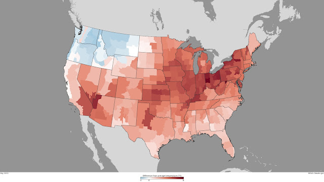
Change in winter temperature from 1980 to now.

Sunday, June 24, 2012
Saturday, June 23, 2012
Rain rain rain
It rained a lot. Some records were broken. It rained more towards Portland. Less rain tomorrow.
Lots of Rain
Very strong low pressure for this time of year causes lots of rain in unpredictable distribution.
We Do Need Some Education
Discovery math is bad. Singapore or Saxon math is good. We can make the switch if we push hard.
Cold Water Along Coasts
Winds from the north & the coriolis effect push surface water away from the coast, bringing cold water up from below.
Saturday, June 16, 2012
Thursday, June 14, 2012
Wednesday, June 13, 2012
June Gloom
The cloud cover in June affects most of the Pacific & West Coast. Get 3-5K' above ground or east of Cascades to avoid.
Monday, June 11, 2012
NWS Troubles
The NWS used funds to cover things without getting permission. Some people retired. No real scandal beyond the underfunding of the NWS.
Sunday, June 10, 2012
Seasonal rainfall patterns
It rains in different seasonal patterns in different regions of the US due to the jet stream. Specifically:
West Coast - 80+% of rain from October to March
Eastern Montana and North Midwest - 50+% of rain from April to June
Inland Southwest - 50+% of rain from July to August
East Coast - Almost uniform rain amounts year round
West Coast - 80+% of rain from October to March
Eastern Montana and North Midwest - 50+% of rain from April to June
Inland Southwest - 50+% of rain from July to August
East Coast - Almost uniform rain amounts year round
Friday, June 8, 2012

Wednesday, June 6, 2012
Clouds Inland
Rising air tends to cause clouds. Cold air off water hits sun-warmed air over land & rises. Strong offshore winds hit slow air over land & rises. Air hits hills & mountains & rises. Thus clouds inland.
Tuesday, June 5, 2012
Venus Transit Final
Head to the coast to see Venus's transit. Downstream of Vancouver Island mountains or Olympia & beyond.

Monday, June 4, 2012
Venus Transit
Tuesday 3:09PM to sunset. Head to SW WA coast or OR coast to have any chance of seeing it. Or watch online.
Saturday, June 2, 2012
Coal Trains
Coal trains produce coal dust in transit, worsen anthropogenic global warming, & send pollution from Asia to the NW. Just say no!
Friday, June 1, 2012
Seattle is cooler than Portland in the summer
Maritime cooling keeps Seattle cooler than Portland in the summer.
Tuesday, May 29, 2012
Forecasting Skill
Forecasting skill - 2-3 days - excellent | 3-4 d - moderate but useful | 5-6 d - marginal | 7-10 d - occasional
Sunday, May 27, 2012
Saturday, May 26, 2012
May Thunderstorm
Quick, windy thunderstorm out of Snoqualmie Pass Friday afternoon. Lots of downed trees & beautiful time lapse video.
Friday, May 25, 2012
Ellensburg Winds
Ellensburg has strong winds due to Snoqualmie Pass & high pressure ridges in the west. Fri/Sat sunny 60s. Sun/Mon overcast sprinkles 60.
Wednesday, May 23, 2012
Monday, May 21, 2012
Eclipse visible in satellite images
Visible satellite images show the eclipse (dark patch moving across image over time).
Saturday, May 19, 2012
Clouds block annular eclipse
High chance of clouds blocking views of annualar eclipse in the NW. Views would have been partial as we're too far north.
Friday, May 18, 2012
Wednesday, May 16, 2012
Climate Forecast Spending Trumps Weather Forecast Spending
We spend more on modeling computers for climate change than for weather.
Sunday, May 13, 2012
Large Temperature Swings
Clear skies, no-to-light winds, and compressional heating lead to large mood temperature swings in the NW this weekend.
Friday, May 11, 2012
Wednesday, May 9, 2012
Windy Coastal Oregon
Southern Oregon (Brookings) / northern California (San Francisco) coast often has 30mph sustained winds during the warm season due to pressure & temperature differentials.
Monday, May 7, 2012
Surface Temperature <> Air Temperature
Surface temperature can be up to 40 degrees F warmer than air temperature. Seeds require specific temperatures to grow.
Saturday, May 5, 2012
Return of the Warmth
Sunday - warm & sunny. Monday - more so - high in 70s. We had large convergence zones recently.
Wednesday, May 2, 2012
Nothing really changes...
People have been complaining about the weather around here since 1855. And still are.
Monday, April 30, 2012
Unanswered Questions
Funnel clouds appear in Skagit County around April (explanation missing from original post). Monday, April 30th was windy.
Tuesday, April 24, 2012
Monday, April 23, 2012
Let's not overreact
Manmade climate change is not causing the extreme weather of late (but will likely cause extreme weather in the latter half of this century).
Friday, April 20, 2012
Warm Weekend & Meteors
Will be warm, but BC near coast will be wet. Lyrid Meteor sightings possible.
Wednesday, April 18, 2012
April 2012 - nice weekends
April has been drier than average & warmer than 2011. Weekend likely 60s & dry, better away from coast.
Monday, April 16, 2012
No Real Rain "Time"
Generally in our region, there is an ever so slightly higher chance of rain from 3-8AM. Less so elsewhere, like Florida.
Friday, April 13, 2012
Wednesday, April 11, 2012
Hasta La Vista, La Nina
La Nina is fading, Sunday should be good weather, & SDOT has more road temperature sensors.
Monday, April 9, 2012
Might be warmer...
It's been warm lately & might continue some. This weekend should be good for hiking east of the Cascades.
Saturday, April 7, 2012
$60 Million to save 60+ billion - going once, going twice...
The US lacks sufficient computational resources for weather forecasting, costing us billions each year. An upgrade would cost $60 million. Do the math.
Thursday, April 5, 2012
Big Cloud Action
Big cloud action due to large temperature difference between ground & sky. 40 years ago (1972) - F3 tornado in Vancouver, WA.
Tuesday, April 3, 2012
Crossover - Like Passover for Weather?
Sometimes its warmer west of the Cascades (winter). Sometimes its not (late spring, summer, fall). This is Crossover! Also, east of the Cascades there are fun things to do (if you don't mind the lack of trees).
Sunday, April 1, 2012
Friday, March 30, 2012
It rained. A lot. More to come.
Record rainfall east of Cascades & greater than normal elsewhere. Late Monday / early Tuesday are going to be very wet. Lots of water vapor headed our way over Pacific (see image). Support public radio.

Wednesday, March 28, 2012
9 Ways to Adjust K-12 Edufailure
Some are on fire about education but aren't making an impact. Here's 9 things to consider changing. Expect a future monologue on textbooks.
Tuesday, March 27, 2012
More Sun (with caveats)
Big jump in sun from January-March, slower increase to July peak. Clouds interfere, but we do alright for our latitude.
Handing over the rains
Starting today, I'm handing over the reins to a new TLDR'er, Ben. Just one of dozens of applicants, Ben passed a very rigorous screening process. So I leave you in good hands.
Ben is a local mathematician who knows a bit about forecasting (energy use, not weather) and follows the weather as a hobby. He loves big storms (snowy and otherwise), enjoys German board games, roughhousing with his dogs, and enjoying life with his partner, Kim.
Everybody set aside your Seattle Freeze for a minute and give Ben a warm welcome. If he does things right (which I'm sure he will), this will be the longest post on the blog for a while.
Sunday, March 25, 2012
Does someone want to take over this blog for me?
CliffMassTLDR got a little too busy to handle his duties as TLDRifier. Anyone want to take over this blog? Low wages, bitter cold, long hours of complete darkness. Safe return doubtful. Honor and recognition in event of success.
Tuesday, March 6, 2012
Thursday, February 23, 2012
Rainy lake
Some lake north of Gold Bar got lots of rain.
In other snowy news, there's an enhanced chance of light snow in some lowland locations on Sunday. No big storm though.
In other snowy news, there's an enhanced chance of light snow in some lowland locations on Sunday. No big storm though.
Wednesday, February 22, 2012
Snow less likely
It will get cold over the weekend, but a major lowland snow event does not look likely. Lots of snow in the mountains, so play it safe up there.
Monday, February 20, 2012
Snow over the weekend?
There's a good chance we'll get colder temps at the end of the week, but we must wait a few days to have a good idea what will happen. Lowland snow is a possibility, but far from certain.
Thursday, February 16, 2012
Prediction for spring
Now that all those prognosticating animals are done, let's look at what the prognosticating scientists have to say.
Spring is predicted to be warmer than normal for the Northwest, making this a far better spring than the last two years.
Spring is predicted to be warmer than normal for the Northwest, making this a far better spring than the last two years.
Tuesday, February 7, 2012
Another fine day. Just one.
Today will be another fine day. But Wednesday will see some degradation--chance of light showers and cooler temps.
Thursday, February 2, 2012
Animals predict the weather
The frog predicts good NW weather for the rest of the winter. The hog predicts 6 more weeks of winter on the East Coast.
I agree with both animals.
I agree with both animals.
Monday, January 30, 2012
Divine retribution for writing about the weather
As punishment for writing about Napavine, the weather gods destroyed a radar and the Mukilteo Ivar's.
Colder than a Witch's ___ in Alaska
The East Coast is warmer than usual, the West Cost is colder, and Alaska is WAY colder. We're talking -77 F.
Friday, January 27, 2012
Where weather data comes from
We get the most weather data from weather satellites, but also from weather buoys, commercial ships, and airplanes.
Forecasts have become much more accurate over the past few decades. This chart shows how much (higher "anomaly correction" = better forecasts):

Forecasts have become much more accurate over the past few decades. This chart shows how much (higher "anomaly correction" = better forecasts):
Wednesday, January 25, 2012
Napavine = Weird
Napavine, WA (just south of Chehalis) has some weird weather:
Speaking of weird, check out what last week's winds did to some waterfront homes in Oregon:

- 25.5 in. of snow last week
- the only place in western Washington to be hit by a tornado last year
- experienced flooding that closed the nearby Interstate for days
- the warmest temperatures in western Washington during the July 09 heat wave (114F)
Speaking of weird, check out what last week's winds did to some waterfront homes in Oregon:
Tuesday, January 24, 2012
UW Stuff
CliffMassTLDR doesn't even know how to TLDR this shitstorm. It's not weather-related, at any rate.
Monday, January 23, 2012
Snow on the peninsula
It's snowing right now, southeast of the Olympics.
Forecasts still change as more data come in. The Seattle Times doesn't understand this.
Forecasts still change as more data come in. The Seattle Times doesn't understand this.
Saturday, January 21, 2012
Lots of new snow in the mountains
Prior to last week, we had less than the average amount of snow in the Cascades. Now we're back to average.

Friday, January 20, 2012
It's over...for now
Warmer temperatures today. But forecast models for next week indicate some heavy rains, strong windstorms, and the arrival of frigid arctic air...
Thursday, January 19, 2012
Oops I accidentally the weather
I forecasted a little freezing drizzle in the South, not that the precipitation would move so far north, so fast. We have several hours more of this snow/sleet/freezing rain event. By tomorrow morning, there should be warmer temps.
Freezing rain/sleet storm
In case you haven't noticed, we're having a rare freezing rain/sleet storm everywhere south of Everett. It's caused by a temperature inversion near the surface, where warm air pushes up above a sub-freezing air mass. Some of this rain is freezing on the way down into ice pellets (sleet), but a lot of it is staying liquid and hitting the ground as freezing rain (freezes on contact with the cold surface).
Today there will be a wintry potpourri: freezing rain, sleet, snow, and rain, until the air warms up enough to turn it all into rain.
Today there will be a wintry potpourri: freezing rain, sleet, snow, and rain, until the air warms up enough to turn it all into rain.
Wednesday, January 18, 2012
Sn'over by 1PM
It's gonna stop snowing around 1PM. More snow tomorrow, but only for Olympia and south. Rain and warmer on Friday, washing the snow away.
Tuesday, January 17, 2012

Update
Newer, more reliable weather models agreeing with the "less snowfall" prediction. Stay tuned for more detail after 9pm tonight.
Less snow predicted for tomorrow
Predictions are now calling for less snow over Seattle tomorrow, probably only 2-5 inches. From Everett to Olympia, there will be less and less more and more snow as you head south.
Update: as some astute readers pointed out, CliffMassTLDR got the prediction of snow intensity backwards. Thanks for catching that.
Update: as some astute readers pointed out, CliffMassTLDR got the prediction of snow intensity backwards. Thanks for catching that.
Monday, January 16, 2012
I am exhausted thinking about all this weather action
There's gonna be some snow Tuesday, but the main event is Wednesday. The next few days have been hard to predict because two airstreams are battling it out up there.
The biggest snowstorm in years
Maybe. You know how those models are, always so fickle. But it looks like everything is going to be delayed by a day. In other words, there was obviously no snow event today; and Wednesday's slush might actually be lots more snow. Details tonight, after these models make up their beautiful minds.
More importantly, my lost dog was just spotted in Mountlake Terrace!
More importantly, my lost dog was just spotted in Mountlake Terrace!
Sunday, January 15, 2012
4 Horsemen of the Snowpocalypse, Harbingers of Slushmagedon
Horseman 1: Yesterday's convergence zone snow
Horseman 2: Today's snow with the coastal trough
Horseman 3. More snow later tomorrow with another trough
Horseman 4: SLUSHMAGEDON on Wednesday AM
Horseman 2: Today's snow with the coastal trough
Horseman 3. More snow later tomorrow with another trough
Horseman 4: SLUSHMAGEDON on Wednesday AM
Saturday, January 14, 2012
Time for a nowcast!
Nowcast: lucky Everett, they got the Convergence Zone. It's snowing there now. Elsewhere, the snow level is 500ft. Snow showers in the mountains, of course.
Colder temperatures and more widespread snow tomorrow, up to a few inches.
More snow late Monday, and then wet snow early Wednesday, turning into rain.
Colder temperatures and more widespread snow tomorrow, up to a few inches.
More snow late Monday, and then wet snow early Wednesday, turning into rain.
Cliff Mass academic paper: TLDR
I published an academic paper about Nowcasting. "Nowcasting" is awesome because instead of requiring a prediction of what the weather will be like in the days ahead, all I need to do is describe the current weather on my blog. Oh, and it creates synergy.
Thursday, January 12, 2012
It's not easy being cold AND wet
A very good chance of some lowland snow Saturday night into Sunday.
Wednesday, January 11, 2012
SNOW, er, I mean "snow?"
This increasing threat of snow SHOULD NOT BE OVERHYPED! Repeat: do not OVERHYPE the increasingly threatening forecast models, which predict colder temperatures and lowland snow from Sunday through Wednesday.
Tuesday, January 10, 2012
Sunday, January 8, 2012
My dog is still missing
When it comes to finding lost dogs, some people suck and some people rule. Please click that link and help me find her.
Thursday, January 5, 2012
Subscribe to:
Posts (Atom)